Almost 500 years after Abraham Ortelius’s birth, what can correspondence with Richard Hakluyt tell us about the mutability of maps?
Archival review by Kōan Brink
Correspondence translated from Neo-Latin by Jared Nabhan
By the time the Elizabethan priest, Oxford professor of geography, and promoter of English colonization Richard Hakluyt penned a letter to Flemish cartographer Abraham Ortelius, Ortelius was already famous for creating his modern atlas the Theatrum Orbis Terrarum (1570). In “‘Imagining European Community on the Title Page of Ortelius’ Theatrum Orbis Terrarum (1570)” Elisabeth Neumann notes that this atlas advanced for the first time a European identity (2009). Where Europe is marked on the world map, the borders—if not perfectly crisp—are recognizably similar to the shape of Europe on a map today. As the reader’s eyes move outward from this continent and begin to travel over straits and oceans, the coastlines morph into shapes at once identifiable and utterly wrong. While earlier navigation and colonization around Africa and Asia gives these continents familiar border lines, the newness and mystery of North and South America renders the continents somehow both too large and too narrow. The title page of Theatrum portrays four female personifications of the known continents; the classicized “Americas” woman holds a severed head, warning of violence and cannibalism. This title page, combined with those maps behind it, depicts not European accuracy but European conceptions of the world in the second-half of the sixteenth century.
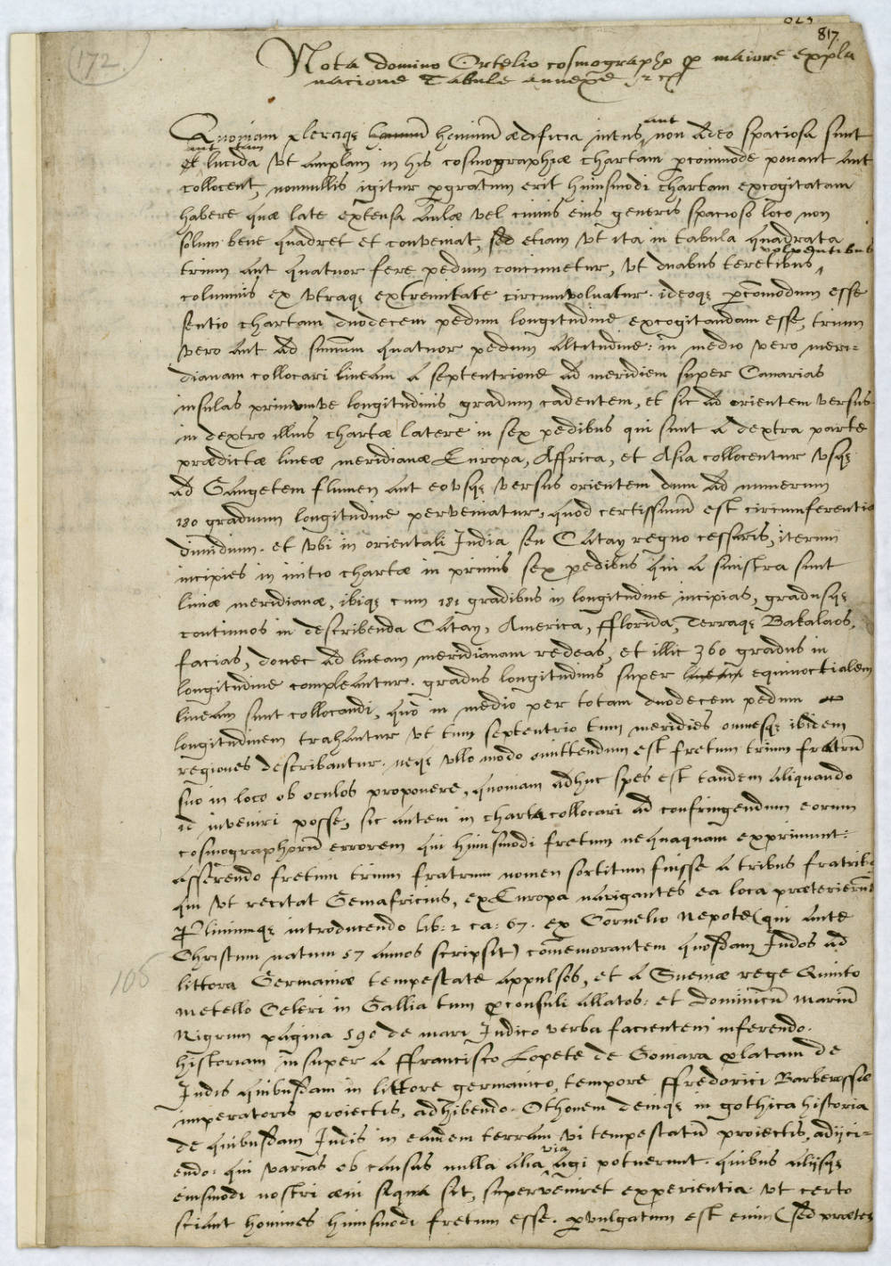
Abraham Ortelius is considered a primary contributor to the Golden Age of Netherlandish cartography. This is partially because he changed the field when he produced his atlas. Theatrum Orbis Terrarum contained 70 maps in a uniform format and was the first of its kind. As the Harry Ransom Center at The University of Texas at Austin notes in its 2005 exhibition Images of the World, before Ortelius’s atlas, individual maps were gathered together by collectors to form made-to-order “Lafreri” atlases; these were named for the leading map publisher of the period. Living in Antwerp, close to Amsterdam, Ortelius existed in the center of a thriving European trade capital and accessed the latest information about global travel and commerce. This is evidenced by a letter from the Englishman Richard Hakluyt that survives at the Ransom Center, part of the Abraham Ortelius Correspondence (HRC 55) which the library acquired in 1969 from the famed antiquarian dealer Hans P. Klaus (alongside a copy of Theatrum and a Blaeu Map).
Instead of demonstrating a people’s accurate understanding of geography, maps more often than not solidify a region or nation-state’s imagination of its self-identity. Maps are, therefore, not an exercise in selfless objectivity, but a consolidation and representation of a ruling person or power’s desires. In the case of the Theatrum title page, Europe is personified on top, on a throne. These elaborate Renaissance title pages craft a perspective by which a reader is supposed to interpret the map itself; they work, if not in tandem, as mutually-influencing spheres. The current administration’s decision to change the name Gulf of Mexico to Gulf of America on digital maps in the United States is not a change for geography’s sake but a change to reflect one government’s perceived possession of a location, highlighting their nation’s importance and its dominance of surrounding waters and coastlines. The announcement of this switch on the current White House website is titled, “Restoring Names That Honor American Greatness.” When one attempts to view the announcement online, this text is quickly obscured by a pop-up invitation to join the White House’s email list, with the tagline “Welcome to the Golden Age!” It is a small, though pertinent, reminder that maps are not formes fixes, but are evolving products of national imaginations.
What appears to be a simple, straightforward, and even boring letter from Hakluyt offering guidance for marking updated, exact longitudinal and latitudinal lines reveals that Ortelius was receiving updates from the most active explorers, colonizers, and travel writers of the day.
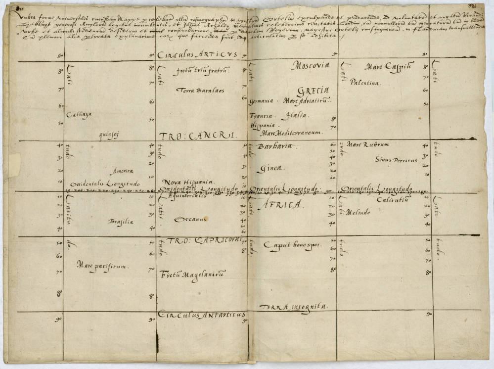
Hakluyt, writing from London to Ortelius in Antwerp, emphasizes “the error of those cosmographers” who omit straits that, in his mind, most certainly exist. The end of his letter contains a striking, multifaceted appeal to the usefulness of Ortelius’s maps for the future English reader:
In this manner, with some laws of the English having been applied, and for the students of both universities, both of Oxford and of Cambridge, and for the citizen of London, you will have made it very pleasing, and you will deliver a map more sellable to all the cities of Europe than any other kind of form. (HRC 55)
The English saw themselves as late to exploration compared with Portugal and Spain, and Hakluyt seems to be self-conscious of this fact in his message to Ortelius, emphasizing the pleasure the highest classes of Englishman at Oxford and Cambridge will feel upon seeing a map that correctly incorporates cartographic and surveyal updates, some from English voyages.
Hakluyt offers instructions for not just updating a map of the world, but instructions for its ideal dimensions, and where such a map should be displayed for viewing:
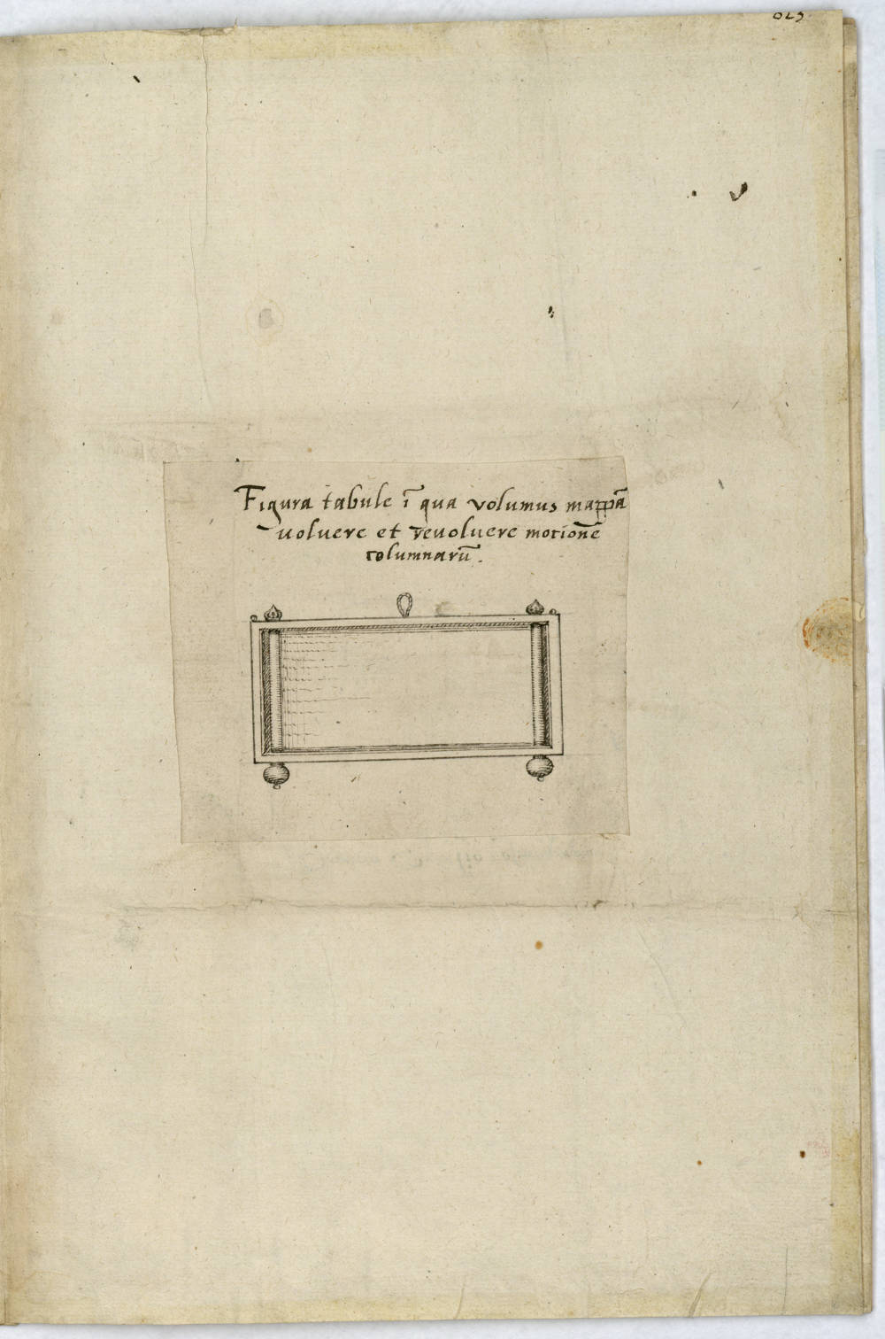
Therefore, it will have been contented by some men that to have devised a chart of this kind, which having been spread out widely, may not only be appropriate for a hall or spacious place of that sort, but also that it be so constructed on a square tablet of roughly three or four feet, so that it may be rolled up around two smooth turning columns on either end. (HRC 55)
Hakluyt wants to emphasize the importance of the learned Englishmen’s ability to obtain an updated map—one that is smaller, scalable, and thus, vastly more profitable for its publishers. A burgeoning printed book trade incentivized this scaling down in physical map size and scaling up in print number. It is also notable that Hakluyt went to Paris in 1583 to gather information for Francis Walsingham (secretary to Queen Elizabeth I) about continental exploration in the Americas and subsequently published The Principall Navigations (1589), a series of travel narratives. By the 1590s, he was actively promoting English expeditions to North America. Peter C. Mancall notes in Richard Hakluyt and the Visual World of Early Modern Travel Narratives that Hakluyt understood that images— not just text—would transform Europeans’ conceptions of the wider world (2012). Hakluyt himself was not a mapmaker or cosmographer, but as evidenced by Navigations and his letter to Ortelius, a logophile with a penchant for strategically communicating and publicizing others’ travels, scientific discoveries, and maps.
In the spatial context Hakluyt emphasizes in his letter, a map of the world is not merely a tool for a head-of-state, but an object appropriate to a variety of interior and exterior spaces in which it might fit. Smaller dimensions allow it to be rolled up, and stored or transported if necessary. Yet this dimensional shift does not correspondingly reduce the map’s ideological function. This particular letter at the Ransom Center contains a gem of an illustrated diagram. Here, Hakluyt’s vision of the map has become smaller than the human who hangs it. In a smaller, portable map, we have evidence that the world is now “manageable”—that we have just enough information to understand it. If that information can be distributed more widely, the world can be conquered.